How it was assembled & hidden
Before there is a campus, there is land — and how it was put together is its own record. The farms weren’t bought by the developer outright. The public Port Authority of Allen County took three-year options on them in 2023–24, for $1,000 apiece, then assigned those options to Bistrozzi on 2025-07-03 — using each option’s §21 “unrestricted right to assign to a nominee.” The public body held the door; a Delaware LLC walked through it.
The land-assembly packet
The public's development authority optioned the farms for $1,000 apiece, assigned the options to a Delaware LLC, and closed — and the one form that records what was paid, the DTE-100, was produced with the price blank. Only the Neighbors parcel's ~$600k for 5 acres is disclosed anywhere. The land was assembled through a public body and handed off; what it cost to convert CAUV farmland into a data-center campus is the blank.
$ ______ · blank What did the public pay to assemble it?
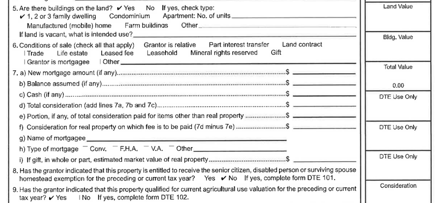
The DTE-100 conveyance-fee value fields were produced blank across the option / closing packets; only the Neighbors parcel (~$600k / 5 ac, ~2× appraisal) is disclosed anywhere.
The Port Authority — a public body — took the options and assigned them to Bistrozzi; the price across the assembled tracts is absent from the one form built to record it. CAUV farmland converting to a data center triggers tax recoupment, but the figure that would size the public's exposure is the blank.
Hold that blank up to the light, though, and it isn’t quite empty. The DTE-100
conveyance-fee statement — the form built to record the price — was produced with its value
lines blank. But the deed the county actually recorded carries a second number the parties
don’t control: a conveyance fee, stamped by the auditor and set by statute
in proportion to the sale price. The Pike Run parcel’s deed shows a $1,041
conveyance fee; the Neff Farms transfer, $25,572.90. A fee that scales with
the price is a price in disguise — the figure the DTE-100 left blank is reconstructable from
the recorder’s own arithmetic at the county’s published rate. The blank is a formality, not a
vault: the public record priced the land even where the parties declined to.
[inference] — the rate is statutory, the back-calculation ours.
But the sharper tell isn’t any single blank — it’s the order. Read the dated instruments in sequence and a pattern falls out: the confidentiality went on first, before the public benefit was voted, before the land was recorded, and long before anyone outside the room could say whose data center this is. The sequence is the argument.
Confidentiality went on first — before the abatement was voted, before the land was recorded, and long before the public could name who is behind it.
- 2025-05-27 ● in the timelineConfidentiality goes on — Mutual NDA (Res #417-25)
The County authorizes a Mutual NDA with Bistrozzi (executed 2025-07-01) — a notify-and-minimize protocol agreed before any public-records request could be answered.
timeline · Res #417-25 (2025-05-27) · NDA executed 2025-07-01 - 2025-07-10 ● in the timelineThe public benefit is voted — CRA approved (Res #548-25)
The 75% / 15-year tax abatement is approved — first deliberated in a closed (G)(8) session on 2025-05-27, behind the NDA.
timeline · Res #548-25 (2025-07-10) - 2025-08-13 ● in the timelineThe land moves — deeds recorded → BISTROZZI LLC
Three Limited Warranty Deeds convey the assembled farms to a Delaware LLC — for “valuable consideration,” the price left blank on the DTE-100s.
timeline · deeds 202508130008300 / …312 / …316 (2025-08-13) - 2026-03-16The customer is confirmed: Google
Google is the data-center customer — [verified]: AEDG's release names a Google official (Molly Kocour Boyle), the allencountydatacenter.com community site launches, and Google testifies to the Ohio Select Committee (Liz Schwab). The point of the sequence is the timing — the public confirmation comes ~10 months after the NDA, last, not first. (In the entity graph Google is an annotation, not a node: it's the customer, not a party to the deal mechanics — a method choice, not an open question.)
AEDG release 2026-03-16 (Molly Kocour Boyle) · allencountydatacenter.com · Liz Schwab (Google) committee testimony · annotation in the graph, not a node
And the sequence doesn’t end where the timeline does. The farm deeds of August 2025 weren’t
the close of the assembly — they were the middle of it. The buying continued well past the
point the public learned whose project this was: a five-acre Neighbors parcel passed to
Bistrozzi on 2026-03-04 for a recited consideration of one
dollar, and a 7.2-acre Pieper tract was conveyed on 2026-04-21 —
not to Bistrozzi LLC, but to a new entity, Bistrozzi Addition LLC,
registered with the Ohio Secretary of State only two weeks earlier (2026-04-08) and organized
by the same Vorys attorney behind the original shells. The campus is still growing, and so is
the cluster of names it grows under — the same pattern the first chapter read, running a year
on. [verified], from the recorded deeds and the SoS filing.